Loading

Polarimetric SAR Imaging System

Designing and Constructing Polarimetric Synthetic Aperture Radar

About for Project

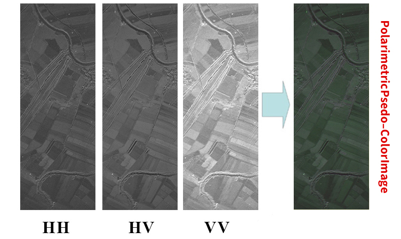
ISRC-PSAR is the first polarimetric radar imaging system in Iran that the specialists in Iranian Space Research Center have succeeded to achieve the technical knowledge of its design and construction. Polarimetric SAR is a kind of radar that can be installed on moving platforms (airplane and UAV) and by simultaneous creation of images in different polarizations (HH-HV-VH-VV) obtains colored radar images from the target area and provides more information compared to gray-scale images of single polarized SAR systems.

Technical specifications

  • – Operating mode: Strip map
  • – Maximum radar range: 15 km
  • – Frequency: 9.6 GHz (X band)
  • – Polarization: full polarimetry (HH-HV-VH-VV)
  • – Incidence angle: 30 to 70 deg
  • – Azimuth and range resolution: better than 1.5 m
  • – Maximum swath: 3000 m

Operational characteristics

  • – The ability of imaging in all hours of the day and night
  • – The ability of imaging in all weather conditions (cloudy, rainy, dusty, …)
  • – Independence of resolution to distance
  • – Possibility of installation on airplane and UAV
Imaging location: Agricultural areas around Kor river in Fars province

Potential customers

  • – Ministry of Agriculture
  • – Disaster Management Organizations
  • – Department of Environment
  • – Natural Resources and Watershed Management Organization
  • – Geological Survey and Mineral Exploration Organization
  • – National Cartographic Center

Competitive advantages

  • – Access to polarimetric SAR technology for the first time in the country
  • – The possibility of use in applications that require constant monitoring of the target area at night and day and in any weather condition
  • – Providing support and after-sales service
  •  – Export Opportunity

Applicability of technology

  • – Classification and monitoring of agricultural products
  • – Seismology and earth fault studies
  • – Geology and mining exploration
  • – Study and monitoring of natural disasters
  • – Oceanography
  • – Urban traffic study
  • – Identification of environmental pollution
  • – Forest studies
  • – Mapping